 EMODnet Product Catalogue
Coordinate reference systems
Type of resources
Topics
Keywords
Contact for the resource
Provided by
Years
Formats
status
Scale 1:
-
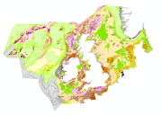
Interim draft habitat output of the EUSeaMap2 (2015) North and Celtic Seas broad-scale predictive model, produced by EMODnet Seabed Habitats. The map was produced using a "top-down" modelling approach using the following input datasets: 1. Seabed Substrate (EMODnet Geology) 2. Bathymetry (EMODnet Bathymetry) 3. Light at the Seabed 4. Wave Base (modeled) 5. Wave energy (modelled) 6. Current energy (modelled) The model, produced in Arc Model Builder (10.1), uses datasets 2 to 4 to determine biological zone, which in combination with seabed substrate and energy data can be used to predict the physical habitat at any one location. The study followed the methodology developped within the EUSeaMap 1 project. For more details about this methodology see documents such as the EUSeaMap 1 final report (Cameron and Askew, 2011), Coltman et al., 2008, or Vasquez et al., 2015 The model was created using raster input layers with a cell size of 0.002dd (roughly 250 meters). The model includes the sublittoral zone only; due to the high variability of the littoral zone, a lack of detailed substrate data and the resolution of the model, it is difficult to predict littoral habitats at this scale. The map follows the EUNIS 2007-11 classification system, supplemented by additional categories in deep sea areas and in areas lacking full data. References: Cameron, A., Askew, N. (eds.), 2011. EUSeaMap - Preparatory Action for development and assessment of a European broad-scale seabed habitat map final report. URL: http://jncc.gov.uk/euseamap Coltman, N., Golding, N., Verling, E., 2008. Developing a broadscale predictive EUNIS habitat map for the MESH study area. 16 pp. URL: https://www.emodnet-seabedhabitats.eu/resources/mesh-archive/ Vasquez, M., Mata Chac├│n, D., Tempera, F., OÔÇÖKeeffe, E., Galparsoro, I., Sanz Alonso, J.L., Gon├ºalves, J.M.S., Bentes, L., Amorim, P., Henriques, V., McGrath, F., Monteiro, P., Mendes, B., Freitas, R., Martins, R., Populus, J., 2015. Broad-scale mapping of seafloor habitats in the north-east Atlantic using existing environmental data. Journal of Sea Research, MeshAtlantic: Mapping Atlantic Area Seabed Habitats for Better Marine Management 100, 120ÔÇô132. doi:10.1016/j.seares.2014.09.011